Tuesday, November 15, 2016

ROCKY MOUNTAIN NATIONAL PARK - A View From the Top ~ "Travel Tuesday"

As a continuation of my previous post on Rocky Mountain National Park, there are three ecosystems at work within the park.  This is the ALPINE (elevations over 11,400 ft.), or as far as I chose to go hike up it that day.  Far enough, really...12,005 ft. above sea level.
The Alpine Visitor Center sits further back in the park, along Trail Ridge Road.  Out back of this beautiful center is a pathway to the top, known affectionately as "Huffer Hill".  A smooth, paved trail to about the halfway point, where it's replaced by large stone steps to the summit.  The Visitor Center itself sits at an elevation of 11,796 ft., meaning I climbed 209 ft. in a very short span...and I understood the meaning of the name.
AND, I had the proper footwear for my trek that day - no cowboy boots - no thongs (yeah, that will come later, as I trekked about the desert landscape in Hawaiian thongs this summer, also).  The view from the top was spectacular, with plenty of photos stops/breathing breaks along the way up.  I chuckled at how many times I heard, "Man!  I thought I was in good shape" (even murmuring in my own head), ascending and descending.
Yes, "unbelievably spectacular" I say, while trying to slow my breathing to steady the camera.  This is the land of the hearty tundra dwellers - marmots, ptarmigans, and the big horn sheep, though the sheep do trek downwards in the winter.
Below the Alpine lie the Sub alpine elevations - anything falling between 9,000 and 11,400 ft.   This is where the shrubberies and trees come back into play, and you'll find most of the larger animals within the park.  We spotted four elk that ran into view at the bottom of that little mountain glacier, as we stood there taking in the beauty.  Elk, deer, bighorn sheep - the Park is home to over 350 Bighorns, which were nearly extinct within it's boundaries in the 1950s.  Binoculars are always a great bet...throw a pair in your trunk - you'll be glad you did.
The third ecosystem within the Park is the Montane - this is below 9,000 ft. in elevation.  Now you're in full-blown pines, firs, and aspens; wildflowers, birds, beaver, otter, and most of the larger animals.  These are the areas that are fed by the runoff from winter snows in the spring and summer months.  These are my Rocky Mountains - spectacular at every turn.
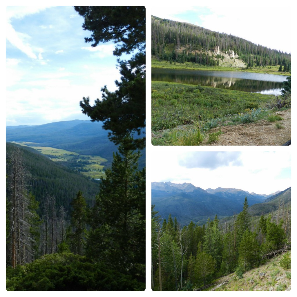
The west side of the Park finds you travelling alongside the Never Summer Mountain Range, opening to views of the valley and town of Grand Lake below.  Upper right photo is of Poudre Lake.
THIS is where the Colorado River starts - just a tiny stream fed by runoff from snow melt, supplying water to some 60 million people downstream. 
The Park - whether you approach east to west, or vice versa - is travelled via Trail Ridge Road.  The innermost portions of this road are closed, due to winter weather conditions, from Mid October to Memorial Day (in May).  You can still travel some of the lower elevations during that time...check ROCKY MOUNTAIN NATIONAL PARK (that's a link right there, that will take you to the NPS website) for road closure information if you are planning on visiting anytime other than May through October.
A parting shot of Grand Lake, CO.  In an attempt to push aside the day to day nonsense that has recently take over my time, I am working my way through Aspen tree fall color shots, taken in September.  The first time I've been home to see it in all it's glory, in about 25 years.  Back soon - get out and see something!

Tuesday, November 1, 2016

ROCKY MOUNTAIN NATIONAL PARK - Celebrating the National Park Service Centennial ~ "Travel Tuesday"

Happy 100th Birthday, National Park Service!
Since its inception on August 25, 1916, at the pen of President Woodrow Wilson (and 44 years after the establishment of Yellowstone National Park), the National Park Service has been entrusted with the care of our National Parks, National Monuments, National Memorials, National Military Parks, National Historic Sites, National Recreation Areas, National Seashores, National Scenic River ways, and more.

The third most visited National Park in 2015 happens to be in my home state of Colorado...
(a quick click on the line above will take you directly to the NPS.gov page).
I am also teaming up with... 
(again, a quick click will take you there)
They've allowed me access to some pretty great graphics for these two posts (too much photo overload for one).  As always, all photos can be clicked and clicked again (including the graphics), for enlargement.

"Cotopaxi is an adventure company that tries to get people outdoors and also, to do good.  We are a Benefits Corporation, which means with every sale we make, a portion is donated to world heath initiatives, and our travel backpacks help us make the biggest impact"...Cotopaxi.com 
RMNP is located in the Front Range of the Rocky Mountains, about 70 miles west of Denver.  Nestled between Estes Park and Grand Lake, the Continental Divide and its eastern and western slopes run through the park; the headwaters of the Colorado River begin here, as well.

The park is filled with awe inspiring mountain views, lakes, and varied environments (from forests to tundra) along with just about any type of western wildlife you could hope to see (that rainy day we spotted bear, deer, elk, and a large gathering of eagles - perched roadside, seeking shelter from the rain).  You'll also find easy access to back-country hiking trails and campsites, for those who want to get off the beaten path.

About a half mile into the entrance that day, we (and about 18 other cars) spied this sow bear and her two large cubs overturning boulders, on a hillside, in search of grubs.  The Park Service Rangers were quick to disperse the crowd - believe me, I was nowhere near these magnificent creatures to get this shot (and only had a normal lens on my camera, hence the bit of blurriness)...ALWAYS respect the animal life, and give them a wide berth!
The park encompasses about 266,000+ acres (or 415 square miles), and is one of the highest national parks in the nation - elevations range from 7,860 to 14,259 feet. Sixty mountain peaks over 12,000 ft. make for some breathtaking viewing.  And, 300 MILES OF HIKING TRAILSfor those so inclined!
For those who'd rather do their sightseeing from the comfort of the car, as we did that day (though we took many opportunities to hike some easier trails, or just pull off for photo ops), the Park offers Trail Ridge Road.  Trail Ridge inspired awe even before the first motorist ever traveled it.  "It is hard to describe what a sensation this new road is going to make", predicted the director of the NPS, in 1931.  "You will have the whole sweep of the Rockies before you, in all directions."  INDEED, you do!  We traveled in fog and low hanging clouds that day, until we reached our first pullout and paved hike...
A quick, easy trail that led to this beautiful vista...our trek started in the fog, and cleared as we approached the end (along with quite a few more folk who didn't seem to mind the rain that day - the backwoods trails will see you far away from crowds like this).
I couldn't have asked for a more perfect window of opportunity when that curtain of fog parted.
Trail Ridge Road (seen ever so faintly in the upper right photo) covers 48 miles between Estes Park and the town of Grand Lake, on the west side of the Park.  Eleven miles of this road take you above timberline (the Parks' pines stop at about 11,500 feet).  The road tops out at 12,183 feet in elevation, while winding across these beautiful mountain tundras.  
Pullouts are plenty, and there's the Alpine Visitor Center at the top, if you really want to stretch your legs (and lungs) - more on that on Thursday.
Again, a click on the bold link will take you directly to Cotopaxi.com, where you can read more about what they are doing to promote our National Park Service, and helping you to get out and "Explore Your Park".  In need of a really great backpack?  Check out their "Gear for Good"  (go ahead and click right there, or RIGHT HERE).

And, one more link to entice you to make a trek of your own to this grand old Park - or one in your own neck of the woods.  Wherever it is, take the time to explore what it has to offer.  Been there before?  Go again!  Relive the memories, and make a few new ones!  Celebrate some of our greatest national treasures - 100 years strong!

I will be back on Thursday with the remainder of the photos I  have for you, plus proof that I do own a great pair of hiking shoes, and didn't hike around in my cowboy boots this time.  Thanks to my dad for another well-thought-out day in the beautiful mountains of home.  Love you more!