Showing posts with label Indian Ruins. Show all posts

Tuesday, November 24, 2015

THANKFUL FOR AMERICA'S OPEN SPACES - An "Eyes Wide Open" Finish of MESA VERDE NATIONAL PARK

A final trek (FINALLY - yes, life gets in the way of blogs sometimes) through THE largest cliff dwelling in North America, which sits in Mesa Verde National Park.  The park is nearing their snowy season now, if not already into it.  Living in the desert SW tends to skew my view of the weather in the rest of the country.  The park is always open, but access to some of the areas is limited during the winter months.
December 18th will mark the 127th year since Richard Weatherill and Charlie Mason, ranchers in the SW corner of Colorado, stumbled upon these magnificent ruins.  Riding atop this mesa, searching for stray cattle during a blizzard, they were met by an astonishing sight across the canyon pictured... 
Three stories high, a magnificent stone city was hidden under a massive rock overhang.  The cattle search was quickly abandoned while the men climbed down, and then up, to explore their discovery for several hours. 
This is Cliff Palace - 150 rooms, 23 kivas and, speculated, home to over a hundred people, it is thought that Cliff Palace was probably a social and "administrative" site of pretty great ceremonial importance in its heyday.  The centerpiece of Mesa Verde, it is one of the finest examples of late prehistoric cliff dwellings in the American Southwest.  Much restoration has been done over the years to preserve it, this is one of the ticketed/guided tours within the park. 
Much controversy surrounds the legacy of Wetherill and Mason, and little credit seems to be given (depending on the story teller) the men in the actual discovery of Cliff Palace.  In the years following their discovery, Wetherill collected thousands of artifacts from this and other area ruins.  However, most all of Wetherill's artifacts ended up in museums, where they could be studied by professional archaeologists and viewed by the public...and MORE sadly, squirreled away in huge, dark storerooms WITHIN these museums, not to be seen by anyone in the public, since acquisition.

The same cannot be said of countless other priceless artifacts stolen by visitors over the years, which ended up in private collections.  To protect the site from further looting and degradation, Congress named Mesa Verde a National Park in 1906.
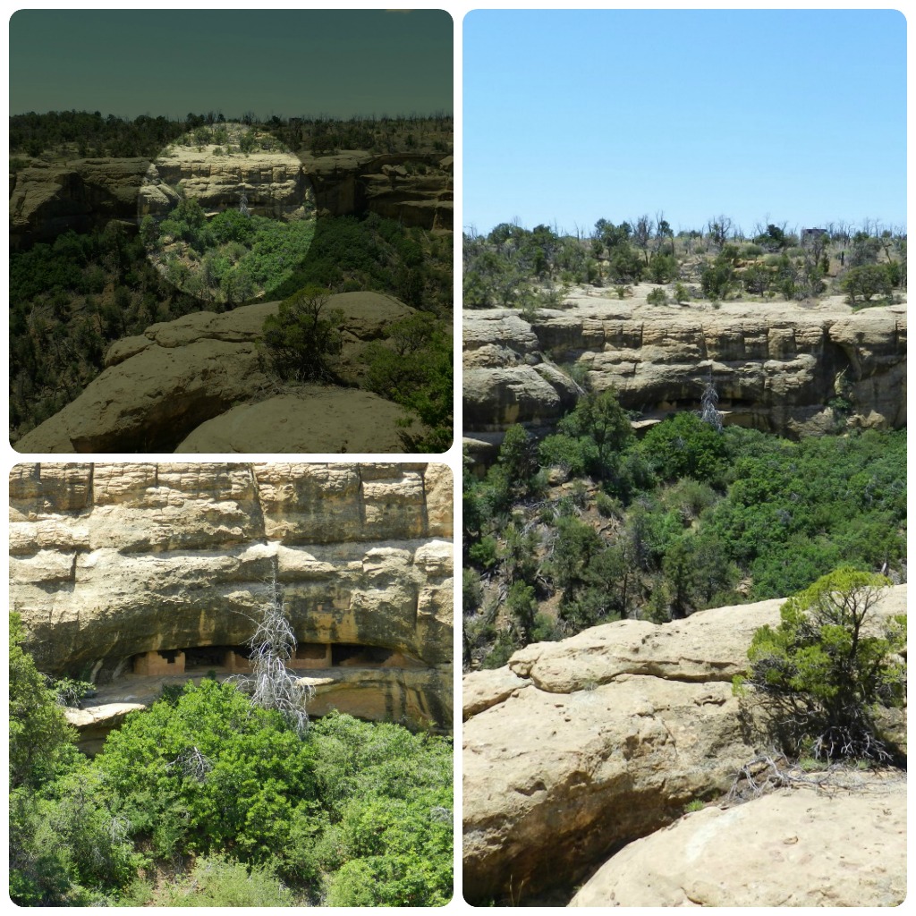
These canyon walls are literally dotted with ruin after ruin, if you keep your eyes wide open, and take the time to look.  Some are nothing more than small storage spaces, or single family dwellings...some a little larger...you just have to look.  This was in the canyon walls opposite the massive dwelling, and sitting under the mesa top where Cliff Palace was originally spotted from.
 Today, this Park protects some 5,000 known archaeological sites, which includes 600 cliff dwellings.
The House of Many Windows, in the same general vicinity.  These, and the "afore-blogged" dwellings are all on the Chapin Mesa, and open year-round, whether viewing from a distance, or taking an up-close and personal tour.  Go in with eyes wide open - you never know where you might spot something a little more spectacular than just beautiful scenery.
On the opposite side of the park, but all within a little less than 20 miles by car, sits Wetherill Mesa - home to beautiful tourist lodging, and even more ancient treasures.  This side of the Park is only open from May to September, weather permitting.  We ran into a hell of a thunderstorm that day, that stopped us from hiking the last ruin, due to waiting out the rain and hitting there at closing time.  If you go, plan ahead and leave yourself plenty of time.  It was actually a blessing in disguise for me to have missed it, as my cowboy boots had just about had it by this tree. 
 Like I said, they're everywhere....
EVERYWHERE!  One of the greatest gifts we have as Americans is the freedom to travel as we please. To get out and discover this great land of ours - the history and treasures it holds - and to LEARN - even the women!  Thankful, as I look at these photos, for a lifetime of being allowed to soak up everything I can!
A parting shot of the ruins of Hemenway House - yep, eyes wide open (go back up a few photos and look, but they are in the center of the mesa, under the large shaded overhang).  Want to explore for yourself...

Happy Thanksgiving from my house to yours...may it be SAFE, happy, and spent with someone you love!

Tuesday, October 20, 2015

MESA VERDE NATIONAL PARK on "TRAVEL TUESDAY"...

The pueblo in the last post (Canyons of the Ancients), is considered "small potatoes" in the area of Cortez, Colorado.  Mesa Verde National Park is the "big gun", if you will - home to over 4,000 known archaeological sites, ranging from pit houses and mesa top dwellings, to the spectacular cliff dwellings.  I've lots to show (I will break it down so it's not overload), and hopefully can impart a little history in the next days, along with my photos.  I'd been to the park many times as a child, and had the fun of taking my own little ones through with my parents, but hadn't been back for 20+ years. This past June I was lucky enough to visit, once more, with my folks.
The area surrounding the park belies what jaw-dropping secrets lie within.  The scenery is barren but beautiful, in its own right.  We stayed at Ute Mountain Casino Hotel on the SW side of Cortez...a hotel I would highly recommend. Quiet, clean, spectacular views of the mesas (the middle photo right also shows Shiprock in the far distance), and tribal owned and operated...yes, that's a TripAdvisor endorsement, right there!  We were treated to sounds of a drum circle from the pavilion in the park, on the weekend night we stayed.  Photos on the left are vistas from the drive up and into the Park.
The Anasazi Indians of Mesa Verde made this their home from about 550 to 1300 AD, flourishing there for approximately 700 years before disappearing.  These cliff dwellings are some of the most notable and best preserved in North America.  Sometime in the late 1100s, after mainly living on the mesa top for 600 years, these Ancestral Puebloans moved over the edge and built pueblos into the overhanging cliffs (most probably for protection from the elements - heat, rain, and snow - and enemies), while still farming the mesa tops.  These cliff dwellings ranged in size from simple one-room storage units, to villages of more than 150 rooms.  
This is the view as you first approach the Spruce Tree House ruin site - the sheer enormity of this ancient ruin is lost in photo depth.  Sadly, most times photos don't translate the same as what you actually take in with the naked eye.  As with all my photos, click (and click again) to enlarge.  The Spruce Tree House site has a museum, restaurant, and several bookstore/souvenir shops located atop the mesa - in addition to covered vantage points where those not wishing to make the trek down can sit in a little shade.  My parents chose to stay on top that day while I walked down the path, into the ruin.
Again, the sheer enormity may not translate as well here - these overhanging cliffs are massive.  When first discovered by ranchers in 1888, a large tree was found growing from the front of the dwelling to the mesa top, allowing access down into the ruin by the ranchers.
Spruce Tree House is the third largest cliff dwelling inside Mesa Verde, and is thought to have been constructed between 1211 and 1278 AD.  The dwelling contains about 130 rooms, and 8 kivas - the large, circular, underground ceremonial chambers.  This is one of the free and unguided tours in the park - you are welcome to wander through it on your own, but DO need to observe the rules and regulations regarding staying off the ruins themselves.  There are Park Rangers available for questions, within the cliff dwelling itself.
Spruce Tree House was built into a natural alcove measuring 216 feet at its widest, and 89 feet, front to back.  It was thought to have housed approximately 60 to 80 people.  These were smaller people, by today's standards...the keyhole looking openings in these photos are actually doorways.  It is thought that the extra sides on these were actually built to provide a "boost" in getting through - hands or elbows placed on the sides, as feet were swung through "on the run", even.  I have been through some of these doors in another of these ruins, and they are tiny.
Spruce Tree House was excavated, and walls stabilized, and opened to visitors in 1908.  Due to the protective overhang of the cliff above, the ruin has deteriorated very little over time, and has required pretty minimal supportive maintenance.
I usually avoid, for some silly reason, people in my shots, but this was needed for perspective.  Upper right (below the vertical log and to the left of the round end of the support beam end, you can see the remnants of an old painting).  Lower right shows some of the small keyhole doorways, above the kiva, (this one would have probably had some sort of thatched roof). 
By the end of the 1200s, the population began migrating south into what are now New Mexico and Arizona.  By 1300 AD, Mesa Verde lay completely silent.  Where exactly did they go?  Lots of theories, but it is believed that they became today's "modern" pueblo inhabitants.  Hang tight - tomorrow we're going on a hike, and then there are more photos and some of the history of the actual discovery of these ancient marvels...lots of ground to cover for an old pair of cowboy boots this week!

Tuesday, October 6, 2015

CANYONS OF THE ANCIENTS NATIONAL MONUMENT on "Travel Tuesday"...

All out-of-town company has gone home, sadly...time for a much needed blog update - the buffalo needs a rest!  Welcome to the Anasazi Heritage Center/Escalante Pueblo at the Canyons of the Ancients National Monument, Dolores, Colorado.  As always, clicking and double clicking on any photo here will enlarge it for you.  
The Four Corners area, where the states of Arizona, Colorado, New Mexico, and Utah meet (the ONLY spot in the United States where this happens), is also home to the modern day Navajo and Ute Mountain Indian Nations, as well as untold Anasazi ruins throughout the area (one of the largest being Mesa Verde, which I will cover next week, ALL week, with a bit more history on the Anasazi peoples - these are pueblos, with Mesa Verde being more cliff dwellings).  On this day, we stopped here - the Canyons of the Ancients National Monument and Anasazi Heritage Center, located 10 miles north of Cortez and 3 miles west of Dolores, both in Colorado.
The Visitor Center houses a beautiful museum displaying archaeological finds from the surrounding ruins, and chock full of historical information regarding the Native Americans who first inhabited these lands.  A small, excavated pueblo sits just outside the front doors of the Center, and was thought to have housed a family of four to six people at the time.  Through the side doors, and up a winding 1/2 mile hill (paved and wheelchair accessible), sits the Escalante Pueblo - a hilltop ruin overlooking the beautiful Dolores River.
The stunning vistas on the way up the "hill" (OK, I have to come clean - this little trail climbs right up the side of this "hill", but with switchbacks so it's not STRAIGHT up.  It IS paved, with park benches along the way for those who need to rest - make SURE you take water!) provide a view of the Sleeping Ute Mountain.  This is a sacred mountain to the Ute Mountain Ute Tribe of today, as well as their ancestors before them.  The Sleeping Ute is said to resemble a Ute Chief lying on his back, with his arms folded across his chest (see the diagram above the actual mountain photos).
The Escalante Pueblo is believed to have been occupied three different times, based on tree-ring dating of wood used in its construction.  Ancestral Pueblo people built the main complex in 1129 AD, and then remained there for at least nine years.  Spanish Explorers Escalante and Dominguez noted this site during their trek across the American Southwest in 1776.
The pueblo is a rectangular block of about 28 rooms, surrounding a large kiva - usually the center point of any pueblo.  The kiva was a subterranean room used for religious ceremonies.  Other rooms of the pueblo were used as work areas, sleeping quarters, and for storage.  
Architecture and masonry indicate that this pueblo was one of the northernmost settlements influenced by the culture of Chaco Canyon, New Mexico, some 100 miles to the south.  There is speculation that such villages were part of an interdependent system of pueblos spread across the Four Corners area.  It is thought that the Escalante Pueblo may have been the hub for religious or social gatherings of people from smaller, surrounding villages.
The hilltop where the pueblo is located (yes, the trudge up the "hill" IS worth it) provides a 360 degree view of everything below and beyond (those are the San Juan Mountains visible to the east, in the top photo).  With the incredible view, for safety purposes of the pueblo from above, and the Dolores River for water below, this was probably just about the perfect setup for these people.
You are free to walk about the top of the ruins, on well-worn paths - there are several covered picnic sites at the top, as well.  As with any archaeological site, staying off walls, and not disturbing the area is paramount to the survival of these ancient sites for future generations.
It is believed that in about 1150 AD, after a short abandonment of the pueblo, that it was briefly reoccupied by people from the local Northern San Juan group of Anasazi Indians.  The third (and final) occupation by these same people was very short, and occurred sometime around 1200 AD.
On your way back down (before leaving the parking lot), do look over the smaller Dominguez Pueblo, which you might have missed when you first arrived (these photos are the Escalante Pueblo - the Dominguez walls can be seen in the second photo up top, among the trees in front of the Visitor Center).  This small site has four rooms with low stone walls - all that remains of a roofed structure that was built about 1123 AD.  Just south of these little rooms sat a dirt-wall kiva, 11 feet in diameter.  It was not possible to stabilize this kiva, so it was reburied to keep it intact.  Although MUCH smaller and simpler, the site is significant in that it shows that these people lived close to the upper pueblo, and their overlapping dates suggest that the two settlements did share some community activities - yep, just like subdivisions of today.
As I said before, the much larger Mesa Verde National Park is in this same proximity, but this is a FAR less crowded (in fact, we saw no one else, save a Park Ranger, that morning) journey back through time.  There is a nominal fee of $3.00 per adult (you can use your Parks Pass for this one) for entrance, and looking over the website for the Canyons of the Ancients, this is just the TIP of the proverbial iceberg for this National Monument, with plenty of hiking trails through a much larger area beyond these two pueblos.  We may have to go back!  Want to go, yourself?  Click here: